News Summary
Severe thunderstorms have hit Southeastern States, with Georgetown under a warning for strong storms, hail, and lightning. The storms have affected several areas, causing power outages, and damage while prompting safety alerts. Expected conditions include hail, strong winds, and the possibility of funnel clouds. With additional storms predicted later in the week, residents are advised to stay alert. Meanwhile, Kentucky has reported significant damage and injuries linked to the storms. Authorities are urging safety precautions and reporting storm damages.
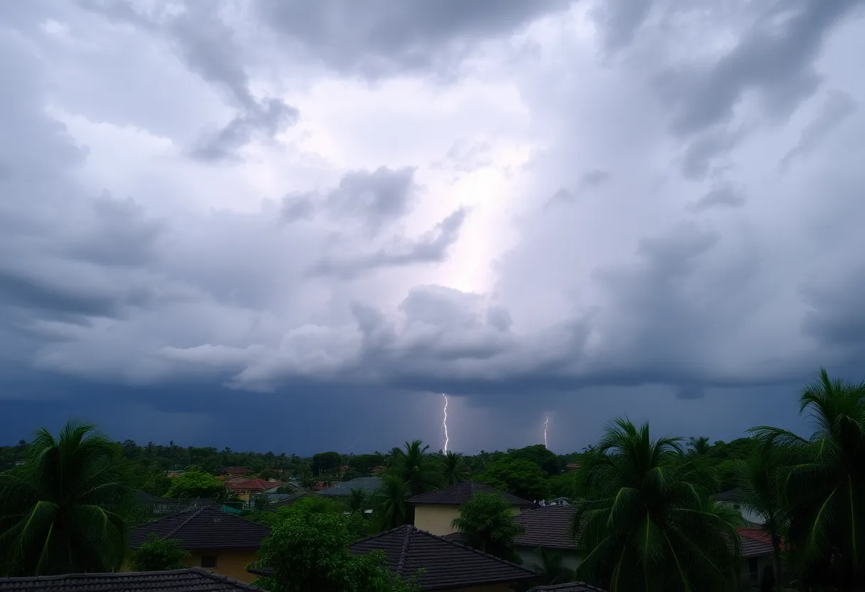
Severe Thunderstorms Bring Mayhem to Southeastern States
Georgetown is currently under the cloud of a severe thunderstorm warning, and it seems like the weather isn’t holding back! The National Weather Service (NWS) Wilmington NC issued an updated alert on Saturday at 6:10 p.m., advising residents to brace themselves for strong thunderstorms lasting until 6:45 p.m. Those within Inland and Coastal Georgetown, along with Williamsburg County, need to stay alert.
What to Expect in Georgetown
Hold onto your hats, folks, because this storm is packing a punch! With expected *marble-sized hail*—that’s around 0.5 inches—and wind gusts racing up to 40 mph, it’s best to secure any loose items outside. This kind of weather can knock down tree limbs and even create minor hail damage to plants. So, if you’ve got a garden, make sure it’s ready for the storm!
Areas Affected
This ominous weather isn’t just hovering above Georgetown. Reports indicate that several areas including Georgetown Memorial Hospital, Lambert, North Santee, Sampit, Graves, Trio, Earle, Andrews, and, of course, Georgetown are all in the line of fire. If you happen to be outside during the storm, it’s wise to duck inside a sturdy building until the tempest passes.
Thunderstorm Conditions
If you catch a glimpse of a funnel cloud, don’t freak out just yet! While conditions are ripe for the formation of brief *weak funnel clouds*, they’re generally harmless. However, in the rare event they do touch down, they can whip up wind gusts exceeding 50 mph. Always report any sightings to the NWS so they can keep everyone informed and safe.
Lightning Alert!
On top of the hail and wind, this storm comes with a side of relentless *cloud-to-ground lightning*. Lightning is no joke—it’s one of nature’s biggest threats! Just remember, if you can hear thunder, you’re close enough to be at risk of a strike. Did you know lightning strikes the United States about *25 million times yearly*? Unbelievably, it causes around 20 fatalities each year! Safety first, everyone! Keep those indoors until the storm blows over.
More Storms Coming
And if you thought this was it, you might want to think again! The forecast predicts more severe weather looming later in the week, particularly forecasting strong to severe thunderstorms coming in on Wednesday evening. It looks like Mother Nature is in a stormy mood!
Storms Across the Region
Meanwhile, Kentucky has not been spared either! Thunderstorms there have resulted in some impressive wind gusts reaching up to 54 mph at Blue Grass Airport, with many counties reporting velocities above 50 mph. The storm wreaked havoc, causing significant damage to Faith Baptist Church in Georgetown, where siding was ripped off. Miraculously, there were no injuries reported.
Power Outages and Consequences
Unfortunately, this storm has also led to tragic news. Two deaths related to the storms have been documented in Indiana, and extensive power outages are affecting Indiana, Michigan, Ohio, and Wisconsin. In Kentucky alone, over 11,000 customers were without power, though that number has thankfully dropped to about 9,000 by 10 a.m.
Safety Measures
On the flip side, Floyd County Schools have faced damages, resulting in closures and prompt responses from maintenance teams to ensure safety. The NWS has been on high alert, urging residents to report any downed trees, power lines, or instances of large hail that could help assess storm damages.
Looking Ahead
As damage assessments continue across various counties in Kentucky, including areas with confirmed EF-1 tornado damage, keep your eyes peeled for possible flooding due to excess rainfall. Some regions in western Kentucky might see a staggering *10 inches of rain* this week. Georgians and surrounding area residents should stay tuned and prepare for further activity.
Stay safe out there, Georgetown, and let’s hope for some sunshine soon!
Deeper Dive: News & Info About This Topic
HERE Resources
Severe Thunderstorm Warning Hits Lowcountry
Beaufort County to Launch 2025 Pavement Rejuvenation Program
Severe Thunderstorm Warning for Oconee County
Severe Thunderstorms Rolling Into Upstate South Carolina
Severe Thunderstorm and Tornado Warnings Impact South Carolina and Atlanta
Severe Weather Alert as Thunderstorms Roll into Midlands, SC
Severe Thunderstorm Alert Issued for Saluda County
Severe Thunderstorms Hit Myrtle Beach, Prompting Warnings
Severe Thunderstorm Alert Issued for Newberry County
Powerful Thunderstorms Shake Chester County
Additional Resources
- Count On 2 News
- Wikipedia: Thunderstorm
- The Herald
- Google Search: Thunderstorm Warnings
- KVUE News
- Google Scholar: Severe Weather Impact
- Kentucky.com
- Encyclopedia Britannica: Thunderstorms
- Count On 2 Weather News
- Google News: Severe Thunderstorm Warnings Georgetown
Author: STAFF HERE HILTON HEAD
The HILTON HEAD STAFF WRITER represents the experienced team at HEREHiltonHead.com, your go-to source for actionable local news and information in Hilton Head Island, Beaufort County, and beyond. Specializing in "news you can use," we cover essential topics like product reviews for personal and business needs, local business directories, politics, real estate trends, neighborhood insights, and state news affecting the area—with deep expertise drawn from years of dedicated reporting and strong community input, including local press releases and business updates. We deliver top reporting on high-value events such as the RBC Heritage golf tournament, Hilton Head Island Wine & Food Festival, and the Gullah Celebration. Our coverage extends to key organizations like the Hilton Head Island-Bluffton Chamber of Commerce and Community Foundation of the Lowcountry, plus leading businesses in tourism and hospitality that power the local economy such as Sea Pines Resort and Sonesta Resort Hilton Head Island. As part of the broader HERE network, including HEREAiken.com, HEREBeaufort.com, HEREChapin.com, HERECharleston.com, HEREClinton.com, HEREColumbia.com, HEREGeorgetown.com, HEREGreenwood.com, HEREGreenville.com, HEREHiltonHead.com, HEREIrmo.com, HEREMyrtleBeach.com, HERENewberry.com, HERERockHill.com, and HERESpartanburg.com, we provide comprehensive, credible insights into South Carolina's dynamic landscape.


