News Summary
A weather alert from the National Weather Service warns residents in Upstate South Carolina about severe thunderstorms expected to roll in tonight. Impacting areas include Greater Oconee, Greater Pickens, Anderson, and Greenville counties, with strong winds reaching up to 50 mph and potential hail. Residents are advised to seek shelter and stay safe as the storms approach.
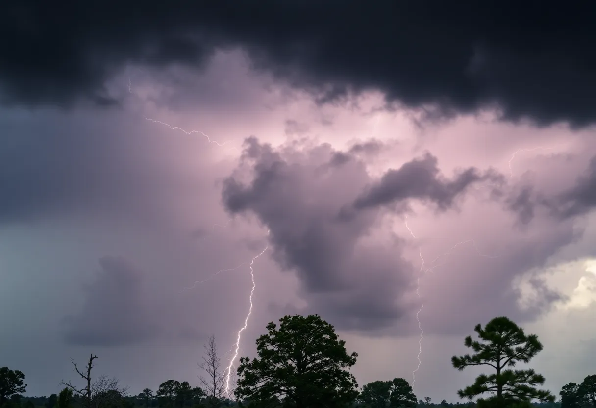
Severe Thunderstorms Rolling Into Upstate South Carolina
Hey there, friends in Upstate South Carolina! If you’re looking to make any outdoor plans tonight, you might want to think again. A weather alert has just been issued by the National Weather Service in Greenville-Spartanburg, warning folks about some strong thunderstorms headed our way. This alert is effective until Saturday at 12:30 a.m., so here’s what you need to know!
Where’s the Action?
The stormy weather is set to impact various areas including Greater Oconee, Greater Pickens, Anderson, Abbeville, and Greenville counties. If you live in or around these places, keep your eyes on the skies! The Doppler radar has already spotted a cluster of strong thunderstorms stretching from just southwest of Pickens to south of Hartwell. These storms are zipping along at a speed of about 35 mph, so they could be near you before you know it.
Buckle Up for Strong Winds and Hail
Expect some intense conditions with wind gusts reaching up to 50 mph and potentially some pea-sized hail, that’s about 0.25 inches in size. Yikes! This might not cause significant damage, but you never know when a gust of wind could knock down a tree limb or send your lawn chair on a wild adventure.
Safety First!
As the storms approach, it’s super important to prioritize your safety. If you’re outdoors, make sure to seek shelter inside a building right away. And if you happen to be near Lake Hartwell, it’s time to get out of the water and head indoors or into a vehicle. Remember, lightning can strike up to 10 miles away from the thunderstorm itself, meaning if you hear thunder, you could be at risk!
Thunderstorm Advice for All
Aside from getting indoors, there are some other smart safety tips to keep in mind during thunderstorms. These storms often bring about hydroplaning, especially if you’re driving. Hydroplaning can happen when your tires are unable to push the water away fast enough, causing your vehicle to slide. If you ever find yourself hydroplaning, the best course of action is to stay calm, steer straight, and gently lift your foot off the accelerator.
Be Prepared for Lightning
Lightning is a major concern during storms. Each year, the United States experiences around 25 million lightning strikes, with an average of about 20 fatalities resulting from these strikes. The risk ramps up as the storm gets closer and reduces when it moves away. So don’t take any chances; it’s better to be safe than sorry!
Storm Impact Locations
Some of the impacted areas include Fork Shoals, Anderson Airport, Starr, Central, Powdersville, Northlake, Honea Path, Vanna, Norris, and Reed Creek. If you’re in any of these locations, now is the time to secure any outdoor items you can!
Wrap Up
Before you settle in for the night, make sure you check the weather updates and ensure you’re ready for whatever Mother Nature throws our way! Storms can be wild, but with a bit of preparation, we can all stay safe and sound while the rain falls and winds howl. Stay cozy and take care!
Deeper Dive: News & Info About This Topic
HERE Resources
Severe Thunderstorm and Tornado Warnings Impact South Carolina and Atlanta
Severe Weather Alert as Thunderstorms Roll into Midlands, SC
Severe Thunderstorm Alert Issued for Saluda County
Severe Thunderstorms Hit Myrtle Beach, Prompting Warnings
Severe Thunderstorm Alert Issued for Newberry County
Powerful Thunderstorms Shake Chester County
Severe Weather Alert for Upstate SC: Thunderstorms and Tornadoes Expected
Beaufort, SC Ranked Among Top Coastal Towns by USA Today
Beaufort Set to Host 2025 Air Show with Blue Angels
Hilton Head Island Considers Beach Parking Permit for Residents
Additional Resources
- Island Packet: Severe Thunderstorm Alert
- Wikipedia: Thunderstorm
- AJC: Storm Damage Reports
- Google Search: Severe Weather Alerts
- Fox 5 Atlanta: Oconee County Weather Alert
- Encyclopedia Britannica: Weather
- Myrtle Beach Online: Latest Weather Updates
- Google News: Tornado Warnings in South Carolina
Author: STAFF HERE HILTON HEAD
The HILTON HEAD STAFF WRITER represents the experienced team at HEREHiltonHead.com, your go-to source for actionable local news and information in Hilton Head Island, Beaufort County, and beyond. Specializing in "news you can use," we cover essential topics like product reviews for personal and business needs, local business directories, politics, real estate trends, neighborhood insights, and state news affecting the area—with deep expertise drawn from years of dedicated reporting and strong community input, including local press releases and business updates. We deliver top reporting on high-value events such as the RBC Heritage golf tournament, Hilton Head Island Wine & Food Festival, and the Gullah Celebration. Our coverage extends to key organizations like the Hilton Head Island-Bluffton Chamber of Commerce and Community Foundation of the Lowcountry, plus leading businesses in tourism and hospitality that power the local economy such as Sea Pines Resort and Sonesta Resort Hilton Head Island. As part of the broader HERE network, including HEREAiken.com, HEREBeaufort.com, HEREChapin.com, HERECharleston.com, HEREClinton.com, HEREColumbia.com, HEREGeorgetown.com, HEREGreenwood.com, HEREGreenville.com, HEREHiltonHead.com, HEREIrmo.com, HEREMyrtleBeach.com, HERENewberry.com, HERERockHill.com, and HERESpartanburg.com, we provide comprehensive, credible insights into South Carolina's dynamic landscape.


