News Summary
Oconee County faces a severe thunderstorm warning with wind gusts up to 60 mph and potential quarter-sized hail. Residents are urged to prepare and seek shelter as the storm approaches from the northwest, affecting areas including Mountain Rest and Salem. Safety measures are emphasized as lightning and hydroplaning risks are also highlighted. As winter weather advisories are in effect, schools in nearby areas are announcing cancellations and delays. Stay informed and safe during these unpredictable weather conditions.
Severe Thunderstorm Warning for Oconee County: What You Need to Know!
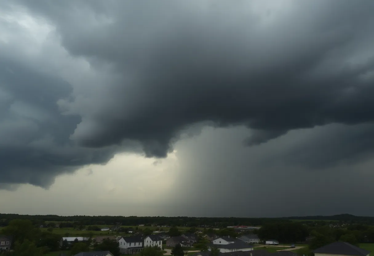
Hey there, folks in Oconee County! It looks like we’re in for quite a weather ride. The National Weather Service has issued an updated severe thunderstorm warning that went out at 10:35 p.m. on Friday. This warning is in effect until 11 p.m., so it’s crucial to buckle up and stay alert!
What’s Coming Our Way?
The thunderstorm brewing is no small potatoes. Expect wind gusts that could whiz up to 60 mph, and there’s a possibility of some quarter-sized hail—that’s about 1 inch, if you’re keeping score. Just a few moments ago, at around 10:33 p.m., the storm was spotted about 9 miles northwest of Walhalla, close to Oconee State Park. It’s chugging along at roughly 25 mph eastward.
Possible Damage
Now, while we all love a good storm story, it’s important to take this seriously. Minor damage to vehicles is expected due to hail, and we might see wind damage to trees and power lines as well. So, keep an eye on your surroundings!
Where is the Storm Headed?
If you’re wondering whether your neighborhood is in the path of the storm, here are some places that could feel the brunt of it:
- Mountain Rest
- Devils Fork State Park
- Salem
- Oconee State Park
- Bad Creek
- Lake Jocassee
- Lake Keowee
Time to check that emergency kit and make sure you’re ready if the lights go out!
Safety First!
The National Weather Service has emphasized the importance of seeking shelter during these storms. If you find yourself caught in this tempest, move to an interior room on the lowest floor of your building. Staying safe should always be the top priority!
Lightning Warnings
This year alone, there are about 25 million lightning strikes nationwide, predominantly during the summer months. While the odds may seem low, lightning causes roughly 20 fatalities each year, and those numbers can spike as thunderstorms roll in. So be conscious about your surroundings when the thunder starts rumbling!
Keep an Eye on the Roads
Another point to consider is the road safety aspect. Did you know that hydroplaning can occur when water builds up in front of your tires while driving on wet roads? It’s a slippery situation, and it’s influenced by tire pressure, tread depth, and speed. Always drive cautiously when the weather is unpredictable!
What Else is Happening?
Over in Georgia and South Carolina, tornado warnings have now expired in certain counties after storms swept through. Thankfully, no damage has been reported in those areas. However, in addition to our thunderstorm concerns, a winter weather advisory has been issued for multiple counties, which means we can also expect some freezing rain and snow.
Cold Weather Preparations
Schools across metro Atlanta and South Georgia have already announced cancellations and delays due to this winter weather watch. If you have kids, keep your ears to the ground for announcements regarding school schedules! To make life a bit easier, remember that the National Weather Service provides guidelines on when to call it a day for school, based on temperature and wind chill. It’s always better to be safe than sorry!
Stay Safe Out There!
So there you have it, Oconee County! Stay informed, stay inside, and keep those loved ones close as we navigate through this storm. Here’s hoping for a safe night for everyone!
Deeper Dive: News & Info About This Topic
HERE Resources
Severe Thunderstorms Rolling Into Upstate South Carolina
Severe Weather Alert for Upstate SC: Thunderstorms and Tornadoes Expected
Snow Flurries Blanket Upstate South Carolina
Severe Thunderstorm Warning Issues in Upstate South Carolina
Upstate South Carolina Schools Transition to E-Learning
Winter Chill is Coming to the Upstate!
South Carolina Residents Affected by Hurricane Helene: Federal Assistance Now Available
Additional Resources
- Herald Online
- WYFF 4
- Island Packet
- Fox 5 Atlanta
- The Weather Channel
- Wikipedia: Severe Weather
- Google Search: Weather Safety
- Google Scholar: Severe Thunderstorm Safety
- Encyclopedia Britannica: Thunderstorm
- Google News: Thunderstorm Warnings
Author: STAFF HERE HILTON HEAD
The HILTON HEAD STAFF WRITER represents the experienced team at HEREHiltonHead.com, your go-to source for actionable local news and information in Hilton Head Island, Beaufort County, and beyond. Specializing in "news you can use," we cover essential topics like product reviews for personal and business needs, local business directories, politics, real estate trends, neighborhood insights, and state news affecting the area—with deep expertise drawn from years of dedicated reporting and strong community input, including local press releases and business updates. We deliver top reporting on high-value events such as the RBC Heritage golf tournament, Hilton Head Island Wine & Food Festival, and the Gullah Celebration. Our coverage extends to key organizations like the Hilton Head Island-Bluffton Chamber of Commerce and Community Foundation of the Lowcountry, plus leading businesses in tourism and hospitality that power the local economy such as Sea Pines Resort and Sonesta Resort Hilton Head Island. As part of the broader HERE network, including HEREAiken.com, HEREBeaufort.com, HEREChapin.com, HERECharleston.com, HEREClinton.com, HEREColumbia.com, HEREGeorgetown.com, HEREGreenwood.com, HEREGreenville.com, HEREHiltonHead.com, HEREIrmo.com, HEREMyrtleBeach.com, HERENewberry.com, HERERockHill.com, and HERESpartanburg.com, we provide comprehensive, credible insights into South Carolina's dynamic landscape.


