News Summary
Residents of Greenville and Spartanburg counties are on high alert due to severe thunderstorm warnings issued by the National Weather Service. With thunderstorms approaching at 15 mph, potential hazards include wind gusts up to 60 mph, hail, lightning, and the risk of tornadoes. Local areas such as Fountain Inn, Woodruff, and Mauldin should seek shelter as the storm moves in. Safety precautions and staying informed are crucial as severe weather conditions persist over the weekend.
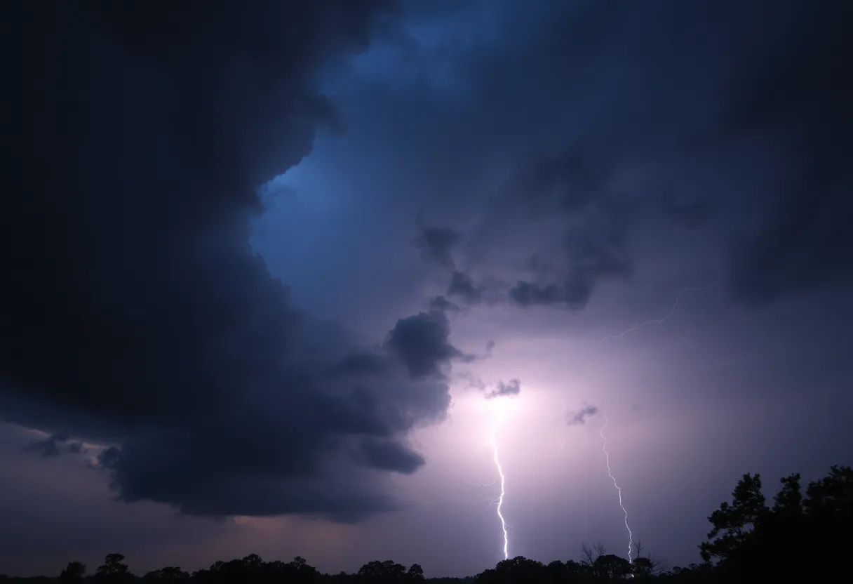
Severe Thunderstorm Warnings Sound for Greenville and Spartanburg Counties – Potential Tornado Threats Loom!
On a tense Saturday evening, residents of Greenville and Spartanburg counties found themselves on high alert as the National Weather Service (NWS) issued a severe thunderstorm warning at 6:07 p.m. This warning is effective until 6:45 p.m. and includes not just Greenville and Spartanburg but also Laurens county.
A Storm on the Move
At the time of the warning, a fierce thunderstorm was brewing just 11 miles east of Greenville’s bustling downtown area, close to locations like Five Forks. The storm is chugging along southeast at a moderate speed of 15 mph, bringing with it the potential for some wild weather.
Wind and Hail Hazards
As folks hunkered down, the NWS warned that wind gusts could whip up to a staggering 60 mph, while quarter-sized hail (that’s right, around 1 inch!) could also be on the agenda. Residents should brace for minor hail damage to cars and potential chaos as winds could knock over trees and power lines.
Areas specifically in the storm’s path include Fountain Inn, Woodruff, Simpsonville, and Mauldin. With hazardous weather on the horizon, the NWS advised people to find safety within an interior room on the lowest floor of any sturdy building.
Earlier Alerts and Conditions
Just a short while earlier at 5:49 p.m., another report from the NWS had warned of strong thunderstorms expected to last until 6:15 p.m. for the same regions. This prior warning indicated wind gusts reaching up to 50 mph and the likelihood of penny-sized hail (a good 0.75 inches).
As radars picked up a robust thunderstorm located 7 miles east of downtown Greenville, the possibility of downed limbs and flying debris became increasingly real. Residents were urged to seek shelter indoors, especially if they were outdoors when the storm began to stir up trouble.
Lightning Danger and Driving Risks
Another aspect of stormy weather is the threat of lightning, which strikes about 25 million times a year across the U.S. Summer thunderstorms often lead to increased chances of lightning strikes, and it peaks right when the storm is overhead. This makes taking cover all the more essential!
Driving during these stormy conditions can be treacherous as well—watch out for hydroplaning! What’s that? Hydroplaning is when water builds up in front of your tires, causing your vehicle to slide uncontrollably. The NWS emphasized that water pressure can lift vehicles up, leading to a lack of control. Quite a scary thought!
Looking Ahead
A hazardous weather outlook is in effect for Saturday and into Sunday, March 15-16, warning residents of a powerful storm system approaching. Meteorologists predict it could pack a punch with strong winds, hefty hail, and even potential tornadoes. Stay alert!
Localized heavy rainfall could usher in minor flooding, especially in the nearby mountains of North Carolina, South Carolina, and Georgia. Wind gusts are expected to vary, predicting 35-50 mph in the North Carolina mountains, and about 25-35 mph in the surrounding areas.
The Weekend Forecast
Saturday’s weather forecast features mostly cloudy skies with temperatures soaring to around 77 degrees and winds gusting as high as 22 mph. As night falls, expect showers and possible thunderstorms after 2 a.m., with a low settling around 62 degrees.
Sunday looks to continue the trend of wet weather with showers and thunderstorms likely before 3 p.m. Anticipate winds of about 18 mph that could ramp up with gusts reaching 34 mph. The forecast does suggest a calming after 10 p.m. Sunday night, featuring mostly clear skies but still a slim chance of a shower or two between 10 p.m. and 2 a.m.
While storms can be daunting, staying informed and prepared is your best bet to weather the storm successfully!
Deeper Dive: News & Info About This Topic
HERE Resources
Severe Thunderstorms Cause Chaos in Southeastern States
Severe Thunderstorm Warning Hits Lowcountry
Beaufort County to Launch 2025 Pavement Rejuvenation Program
Severe Thunderstorm Warning for Oconee County
Severe Thunderstorms Rolling Into Upstate South Carolina
Severe Thunderstorm and Tornado Warnings Impact South Carolina and Atlanta
Severe Weather Alert as Thunderstorms Roll into Midlands, SC
Severe Thunderstorm Alert Issued for Saluda County
Severe Thunderstorms Hit Myrtle Beach, Prompting Warnings
Severe Thunderstorm Alert Issued for Newberry County
Additional Resources
- WYFF4: Severe Weather Timing
- Greenville Online: Tornado Outlook
- Fox Carolina: Severe Thunderstorm Warning
- Wikipedia: Severe Weather
- Island Packet: Weather News
- Encyclopedia Britannica: Thunderstorm
- WYFF4: Greenville Weather Update
- Google Search: Severe Weather Alerts
- Storyful: Weather Video
- Google News: Severe Weather
Author: STAFF HERE HILTON HEAD
The HILTON HEAD STAFF WRITER represents the experienced team at HEREHiltonHead.com, your go-to source for actionable local news and information in Hilton Head Island, Beaufort County, and beyond. Specializing in "news you can use," we cover essential topics like product reviews for personal and business needs, local business directories, politics, real estate trends, neighborhood insights, and state news affecting the area—with deep expertise drawn from years of dedicated reporting and strong community input, including local press releases and business updates. We deliver top reporting on high-value events such as the RBC Heritage golf tournament, Hilton Head Island Wine & Food Festival, and the Gullah Celebration. Our coverage extends to key organizations like the Hilton Head Island-Bluffton Chamber of Commerce and Community Foundation of the Lowcountry, plus leading businesses in tourism and hospitality that power the local economy such as Sea Pines Resort and Sonesta Resort Hilton Head Island. As part of the broader HERE network, including HEREAiken.com, HEREBeaufort.com, HEREChapin.com, HERECharleston.com, HEREClinton.com, HEREColumbia.com, HEREGeorgetown.com, HEREGreenwood.com, HEREGreenville.com, HEREHiltonHead.com, HEREIrmo.com, HEREMyrtleBeach.com, HERENewberry.com, HERERockHill.com, and HERESpartanburg.com, we provide comprehensive, credible insights into South Carolina's dynamic landscape.


