Newberry County, August 22, 2025
News Summary
Newberry County is under a severe thunderstorm alert issued by the National Weather Service. Residents should prepare for wind gusts of up to 50 mph and pea-sized hail. The storm is expected to affect several locations, including Newberry College and nearby areas, until 7:30 p.m. Safety measures are advised, particularly for those driving, as hydroplaning could occur. Already, significant power outages have been reported, with emergency services mobilizing to address the damages. Stay informed and seek shelter if necessary.
Severe Thunderstorm Alert Hits Newberry County!
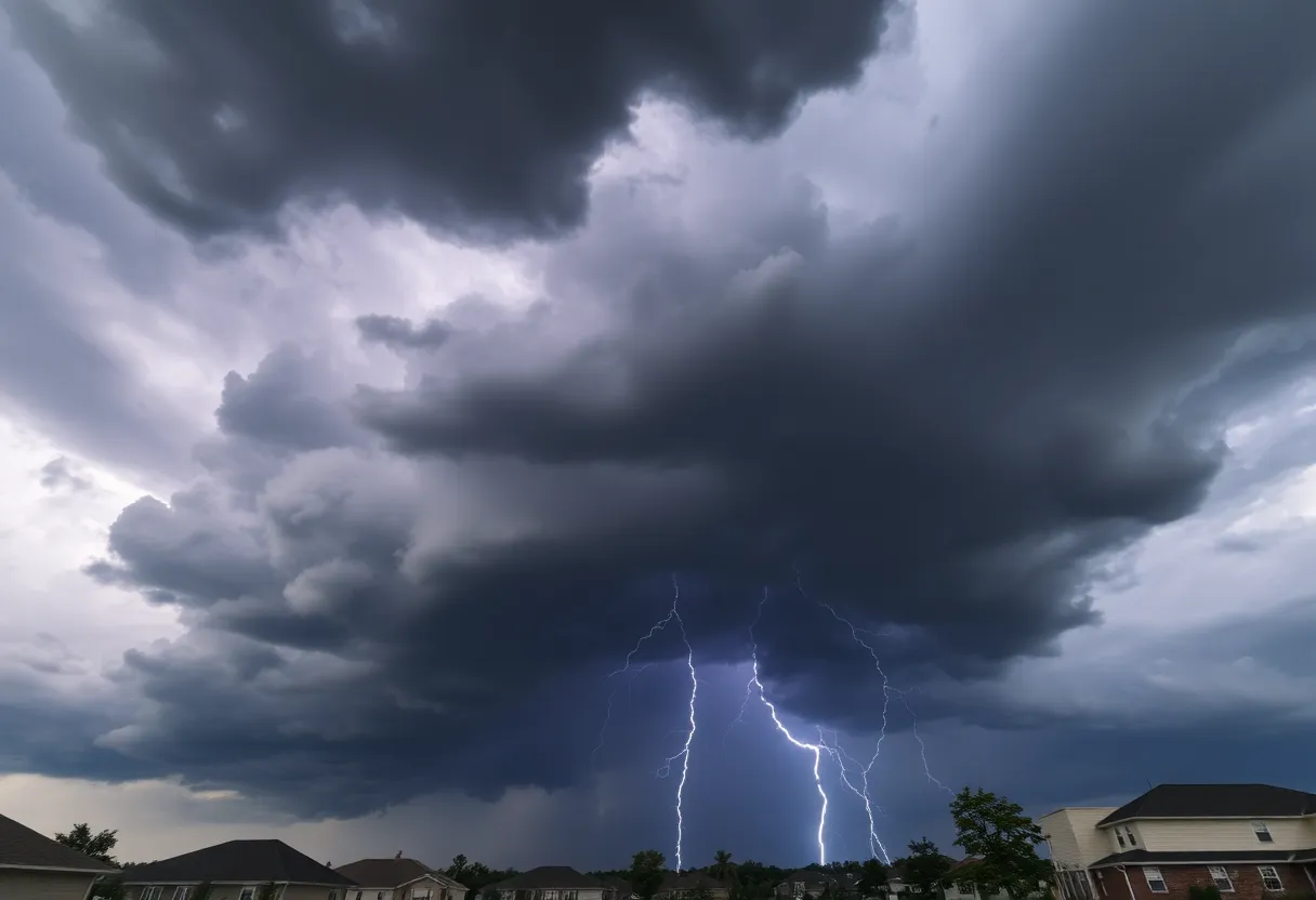
Newberry County, the lovely home of the Newberry College and charming suburbs, is bracing itself for a robust thunderstorm expected to roll in with all its thunderous might this evening. An updated weather alert was issued at 7:01 p.m. by the National Weather Service Columbia, warning residents that the thunderstorm is set to rock the area until 7:30 p.m.
What’s Happening Out There?
According to the alert, the storms could unleash wind gusts of up to 50 mph and a chance of pea-sized hail – that’s a mere 0.25 inches, but it’s certainly nothing to shrug off! Doppler radar picked up a particularly strong storm brewing over Newberry College, making its way south at a swift 15 miles per hour. So if you happen to find yourself outdoors, now is the time to seek shelter inside a cozy building.
Watch Out for Wind Damage
The gusty winds might just do a number on tree limbs, and don’t be surprised if some unsecured objects join the airshow as they’re knocked around! This could lead to some minor damage to outdoor items like patio furniture or holiday decorations – so it’s a good idea to bring them indoors.
Locations Under Watch
This storm is not picky; it’s spreading its reach across several notable locations including:
- Newberry
- Newberry County Airport
- Newberry College
- Pomaria
- Silverstreet
- Newberry County Detention Center
- US-176
- SC-34 Crossroads
- Belfast Wildlife Management Area
- Chappells Fire Station
- Bush River Fire Station
- Vaughnville
- Enoree Ranger District Office
- Chappells
- Kinards
Additionally, travelers on Interstate 26 should be aware, as the storm might disrupt conditions between mile markers 64 and 81.
Common Safety Measures
Speaking of safety, the National Weather Service strongly advises caution for folks who are out and about. Seek shelter immediately if outdoors, and stay informed about the weather if you must venture outside. With storm conditions, the likelihood of lightning strikes escalates rapidly, especially when the storm comes right above you.
A Glimpse at Hydroplaning
As it pours, something to watch for is hydroplaning— that’s when a vehicle slides uncontrollably on wet roads because water accumulates in front of the tires. This can happen due to speed, tire tread conditions, and the amount of water on the road, so it’s best to drive cautiously.
Power Outages and Rescue Efforts
Local officials have already reported several trees and power lines down from the tempest, with approximately 140,000 power outages occurring across South Carolina. Those in Richland County are looking at around 16,000 outages, while nearly 30,000 are affected in Lexington County. Emergency services, alongside the South Carolina Department of Transportation and power crews, are mobilizing to tackle the resulting damages.
Looking Ahead
Just as the clouds are starting to lift this evening, it seems another wave of storms is likely for Sunday morning, possibly showcasing more fury later in the day. So folks, keep your eyes peeled and stay safe!
FAQs
What should I do during a severe thunderstorm warning?
Seek shelter indoors, away from windows, and listen for further updates from the National Weather Service.
How can I stay safe while driving in storms?
Drive slowly and keep a safe distance from other vehicles. Avoid roads with standing water to minimize the risk of hydroplaning.
What is hydroplaning, and how can I prevent it?
Hydroplaning occurs when water on the road causes your tires to lose contact, making control difficult. Ensure your tires are well-maintained and reduce your speed in wet conditions.
| Feature | Description |
|---|---|
| Wind Gusts | Up to 50 mph |
| Hail Size | Pea-sized (0.25 inches) |
| Effect Duration | Until 7:30 p.m. |
| Power Outages | Estimated 140,000 across SC |
Deeper Dive: News & Info About This Topic
HERE Resources
EF-1 Tornado Hits Clarendon County Amid Severe Storms
Severe Thunderstorm Warnings Issued in South Carolina
Severe Thunderstorm Warning for Southeastern Orangeburg
Discover Charming Small Towns in South Carolina for Your Summer Getaway
Major Weather Changes Unfolding in Charleston
Severe Weather Hits South Carolina and Maryland
Thunderstorm Warnings Issued for Orangeburg Area
Tragic Incident on Hilton Head Island: Woman Found Unresponsive
Investigation Begins on Hilton Head Island After Woman Found Dead
Severe Thunderstorm Warnings in Upstate South Carolina
Additional Resources
- Herald Online: Severe Thunderstorm Alert
- Wikipedia: Severe Thunderstorm
- The State: Weather News
- Google Search: Severe Thunderstorm Safety
- WLTX: South Carolina Power Outages
- Encyclopedia Britannica: Thunderstorm
- ABC Columbia: Storms in the Midlands
- Google News: South Carolina Weather
- Weather.com: Newberry SC Weather
Author: STAFF HERE HILTON HEAD
The HILTON HEAD STAFF WRITER represents the experienced team at HEREHiltonHead.com, your go-to source for actionable local news and information in Hilton Head Island, Beaufort County, and beyond. Specializing in "news you can use," we cover essential topics like product reviews for personal and business needs, local business directories, politics, real estate trends, neighborhood insights, and state news affecting the area—with deep expertise drawn from years of dedicated reporting and strong community input, including local press releases and business updates. We deliver top reporting on high-value events such as the RBC Heritage golf tournament, Hilton Head Island Wine & Food Festival, and the Gullah Celebration. Our coverage extends to key organizations like the Hilton Head Island-Bluffton Chamber of Commerce and Community Foundation of the Lowcountry, plus leading businesses in tourism and hospitality that power the local economy such as Sea Pines Resort and Sonesta Resort Hilton Head Island. As part of the broader HERE network, including HEREAiken.com, HEREBeaufort.com, HEREChapin.com, HERECharleston.com, HEREClinton.com, HEREColumbia.com, HEREGeorgetown.com, HEREGreenwood.com, HEREGreenville.com, HEREHiltonHead.com, HEREIrmo.com, HEREMyrtleBeach.com, HERENewberry.com, HERERockHill.com, and HERESpartanburg.com, we provide comprehensive, credible insights into South Carolina's dynamic landscape.


