Charleston, August 18, 2025
News Summary
Residents of Charleston and Colleton Counties were issued severe thunderstorm warnings on Sunday afternoon as powerful storms approached. With wind gusts reaching up to 60 mph and the risk of flash flooding, the National Weather Service urged residents to stay alert and take safety precautions. The thunderstorms are expected to bring heavy rainfall and possible damage to property. Locals are advised to monitor weather updates and avoid driving through flooded areas.
Severe Thunderstorm Warnings Shake Charleston and Colleton Counties
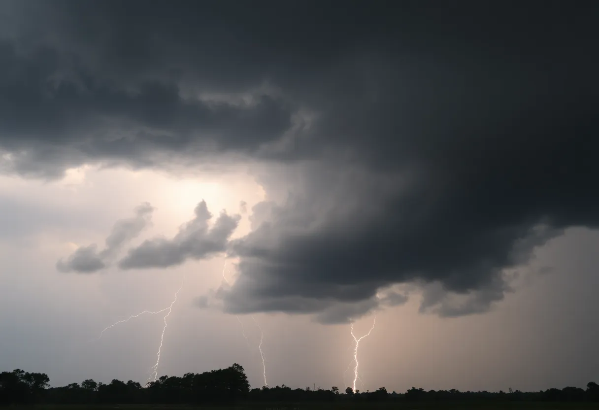
This Sunday afternoon, residents of Charleston and Colleton Counties were met with exciting yet concerning news—severe thunderstorm warnings have been issued! As the clock struck 4:21 p.m., the National Weather Service (NWS) Charleston SC alerted everyone about strong thunderstorms rolling through until 4:45 p.m., especially targeting Inland Colleton.
What’s in store for those living in the area? Well, hold on to your hats because winds could gust up to an impressive 50 mph—think about that! These winds are strong enough to topple tree limbs and send unsecured objects flying. Just imagine a flying lawn chair or some rogue garden decorations!
The Doppler radar clocked a powerful thunderstorm over Hendersonville, moving west at a steady pace of 20 mph. So if you’re from places like Walterboro, Ritter, and Colleton Medical Center areas, or even near the Lowcountry Regional Airport, keep your eyes peeled! The alert stretches across I-95 in South Carolina, covering mile markers 42 through 61, which means plenty of folks need to be on alert.
With torrential rainfall expected, there’s a heightened risk of flash flooding. Drivers are strongly warned not to drive through flooded roadways. Staying informed is crucial, so always have your NOAA Weather Radio All Hazards, TV, or local news stream nearby for real-time updates on the ever-changing weather.
It’s not just today; reports are coming in that Saturday afternoon around 1:30 p.m. brought a similar alert for Dorchester and Charleston counties. Those areas dealt with the same exhilarating yet worrisome wind gusts of up to 50 mph and thunderstorms moving near Magnolia Gardens. Areas like North Charleston, West Ashley, and Hollywood were also in the storm’s path, proving that wild weather isn’t biased toward anyone!
As if that wasn’t enough, the risk of lightning is something to keep on your radar. Did you know there are approximately 25 million lightning strikes in the U.S. every year? Unfortunately, these storms result in about 20 fatalities annually, mostly during the summer months when thunderstorms are most common. The chances of a lightning strike spike as the storm approaches, and they peak when the storm is right overhead.
Safety Tips During Thunderstorms
Staying safe during such storms is key. Experts recommend seeking shelter in a strong building and steering clear of windows. If you’re driving, be cautious of hydroplaning, which happens when a vehicle glides uncontrollably on a wet road. Hydroplaning occurs when water builds up in front of the tire faster than it can be displaced—resulting in the vehicle floated on a thin layer of water. If you can, wait until these storms pass.
Even the following Tuesday, at around 7:49 p.m., another severe thunderstorm warning was issued for Charleston County, complete with wind gusts predicted at a staggering 60 mph. These storms can pack a punch and cause significant damage, including potential risks to roofs, trees, and the structures themselves.
If you’re in the line of these storms, the best thing to do is to stay updated and check in regularly with local forecasts. If you experience any damage from the storm, and it’s safe to do so, kindly report the situation directly to the National Weather Service. Together, we can keep our communities informed and safe!
FAQ Section
What is a severe thunderstorm warning?
A severe thunderstorm warning means that severe thunderstorms are occurring or will occur shortly in your area, posing risks such as high winds, hail, and heavy rainfall.
How strong are the winds expected during these storms?
Winds are expected to gust up to 60 mph, capable of causing damage and knocking down trees and power lines.
What should I do if I’m driving during a thunderstorm?
It’s best to pull over safely, find a sturdy shelter, and wait until the storm passes. Avoid driving through flooded areas to prevent hydroplaning.
How can I stay updated on the weather conditions?
You can stay informed through sources like NOAA Weather Radio All Hazards, local news broadcasts, or weather apps on your mobile device.
Deeper Dive: News & Info About This Topic
HERE Resources
Severe Thunderstorms Impact Upstate South Carolina
Beaufort, South Carolina Faces Flash Flood Warning Amid Heavy Rainfall
Severe Thunderstorm and Flash Flood Alerts for Charleston, SC
Hilton Head Island Implements Guidelines for Souvenir Collection and Wildlife Preservation
Hurricane Erin Strengthens to Category 5 Storm
Severe Thunderstorm Alerts Issued for York and Chester Counties
Severe Weather Causes Havoc in Jasper County, Mississippi
Severe Thunderstorms Hit Spartanburg, South Carolina
Severe Thunderstorm Warnings for Coastal Colleton and Beaufort Counties
Severe Thunderstorm Warnings for South Carolina Counties
Additional Resources
- Count on 2 News: Severe Thunderstorm Warning Issued
- Wikipedia: Thunderstorm
- Island Packet: Weather News
- Google Search: Thunderstorm Warning
- ABC News 4: Severe Thunderstorm Warning
- Encyclopedia Britannica: Thunderstorm
- Live 5 News: Multiple Counties Under Thunderstorm Warning
- Google News: Thunderstorm
Author: STAFF HERE HILTON HEAD
The HILTON HEAD STAFF WRITER represents the experienced team at HEREHiltonHead.com, your go-to source for actionable local news and information in Hilton Head Island, Beaufort County, and beyond. Specializing in "news you can use," we cover essential topics like product reviews for personal and business needs, local business directories, politics, real estate trends, neighborhood insights, and state news affecting the area—with deep expertise drawn from years of dedicated reporting and strong community input, including local press releases and business updates. We deliver top reporting on high-value events such as the RBC Heritage golf tournament, Hilton Head Island Wine & Food Festival, and the Gullah Celebration. Our coverage extends to key organizations like the Hilton Head Island-Bluffton Chamber of Commerce and Community Foundation of the Lowcountry, plus leading businesses in tourism and hospitality that power the local economy such as Sea Pines Resort and Sonesta Resort Hilton Head Island. As part of the broader HERE network, including HEREAiken.com, HEREBeaufort.com, HEREChapin.com, HERECharleston.com, HEREClinton.com, HEREColumbia.com, HEREGeorgetown.com, HEREGreenwood.com, HEREGreenville.com, HEREHiltonHead.com, HEREIrmo.com, HEREMyrtleBeach.com, HERENewberry.com, HERERockHill.com, and HERESpartanburg.com, we provide comprehensive, credible insights into South Carolina's dynamic landscape.


