News Summary
The National Weather Service has issued a Severe Thunderstorm Watch for Upstate South Carolina, with storms expected to affect several counties including Abbeville and Greenwood. Residents should prepare for strong thunderstorms featuring wind gusts of up to 40 mph and possible penny-sized hail. The storms could cause hazardous conditions, including lightning and hydroplaning. Shelter is advised during the storm, and lingering showers may continue into Friday. Note that temperatures will drop over the weekend but are expected to recover early next week.
Severe Thunderstorm Watch Hits Upstate South Carolina!
Hold on to your hats, folks! The National Weather Service has issued a Severe Thunderstorm Watch for Upstate South Carolina as storms roll into the area, and it could get a bit bumpy tonight!
When and Where?
That’s right, the alert was issued late last night on May 8, 2025, at precisely 11:52 p.m. The storms are expected to stick around until 12:30 a.m. on May 9.
The counties that may see the brunt of this wild weather include Abbeville and Greenwood. But don’t let those borders fool you! Areas like Coronaca, Bradley, Promised Land, Ninety Six, Epworth, Troy, and Callison could also be in for a show!
What to Expect?
As for the weather, brace yourselves for some strong thunderstorms rolling in with wind gusts of up to 40 mph and the potential for penny-sized hail measuring about 0.75 inches. Yikes! This storm is definitely packing a punch!
The storm is currently located about 9 miles southeast of Abbeville and is moving northeast at a speed of 30 mph. That means it’s coming in fast, and the NWS has reminded us that gusty winds can easily knock down tree limbs and blow around any unsecured outdoor items.
Stay Safe!
It’s important to take care of yourself and your belongings during this storm, so if you’re outdoors when the storm hits, it’s a good idea to seek shelter indoors. Remember, safety first!
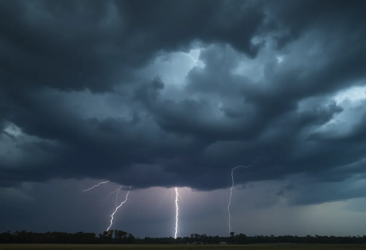
Lightning and Rain: The Stats
Did you know that in the U.S., there are about 25 million lightning strikes each year? Most of those happen during summer storms, and sadly, they result in around 20 fatalities annually. As this thunderstorm approaches, the risk of lightning strikes increases, reaching its peak when the storm is directly overhead. Keep your distance from tall structures and remember that lightning loves to play!
Hydroplaning is another risk factor during storms, occurring when a vehicle loses control on wet roads. It happens when water builds up in front of tires, and with just a little bit of rain, it can become a danger. Make sure to keep your speed down and be extra cautious!
Looking at the Weekend
Weather-wise, you’ll notice a mix of clouds with high temperatures hovering around 84°F today. There could be scattered showers or thunderstorms throughout the day. The timing for the storms suggests that places like Oconee and Anderson can expect issues as early as 7 p.m., followed closely by the Greenville area by 8 p.m., and then Spartanburg around 9 p.m..
After tonight’s storm shenanigans, some leftover showers might linger into Friday afternoon and early evening, so hang onto your umbrellas!
What’s Next?
And for those wondering about the weekend, temperatures will likely drop to around 60°F by Saturday. But not to worry! Early next week, warmer and sunnier days are expected to return, with highs reaching near 80°F. So, there’s light at the end of the rainy tunnel!
Stay tuned, stay safe, and let’s hope for the best as these storms roll through!
Deeper Dive: News & Info About This Topic
HERE Resources
Severe Thunderstorm Warning for McCormick and Edgefield Counties
Hilton Head Braces for Severe Thunderstorms This Weekend
Brenham, Texas Community Mourns Loss of Young Girl Due to Flood
Myrtle Beach on Thunderstorm Alert: Stay Safe!
Multiple Fires in Savannah Highlight Community Safety Concerns
Beaufort County Faces Brush Fires and Suspicious Blazes
Severe Thunderstorm Alerts in Myrtle Beach and Conway
Severe Thunderstorm Warnings Issued for Myrtle Beach Area
Severe Weather Alert for Central South Carolina – Thunderstorms on the Way!
Severe Thunderstorm Warnings Issued for Spartanburg County, SC
Additional Resources
- Island Packet
- Wikipedia: Severe Thunderstorm
- WFXG
- Google Search: Severe weather South Carolina
- Myrtle Beach Online
- Google Scholar: Thunderstorm impacts
- WYFF4
- Encyclopedia Britannica: Thunderstorm
- Weather.com
- Google News: Thunderstorm warning South Carolina
Author: STAFF HERE HILTON HEAD
The HILTON HEAD STAFF WRITER represents the experienced team at HEREHiltonHead.com, your go-to source for actionable local news and information in Hilton Head Island, Beaufort County, and beyond. Specializing in "news you can use," we cover essential topics like product reviews for personal and business needs, local business directories, politics, real estate trends, neighborhood insights, and state news affecting the area—with deep expertise drawn from years of dedicated reporting and strong community input, including local press releases and business updates. We deliver top reporting on high-value events such as the RBC Heritage golf tournament, Hilton Head Island Wine & Food Festival, and the Gullah Celebration. Our coverage extends to key organizations like the Hilton Head Island-Bluffton Chamber of Commerce and Community Foundation of the Lowcountry, plus leading businesses in tourism and hospitality that power the local economy such as Sea Pines Resort and Sonesta Resort Hilton Head Island. As part of the broader HERE network, including HEREAiken.com, HEREBeaufort.com, HEREChapin.com, HERECharleston.com, HEREClinton.com, HEREColumbia.com, HEREGeorgetown.com, HEREGreenwood.com, HEREGreenville.com, HEREHiltonHead.com, HEREIrmo.com, HEREMyrtleBeach.com, HERENewberry.com, HERERockHill.com, and HERESpartanburg.com, we provide comprehensive, credible insights into South Carolina's dynamic landscape.


