Charleston, South Carolina, August 17, 2025
News Summary
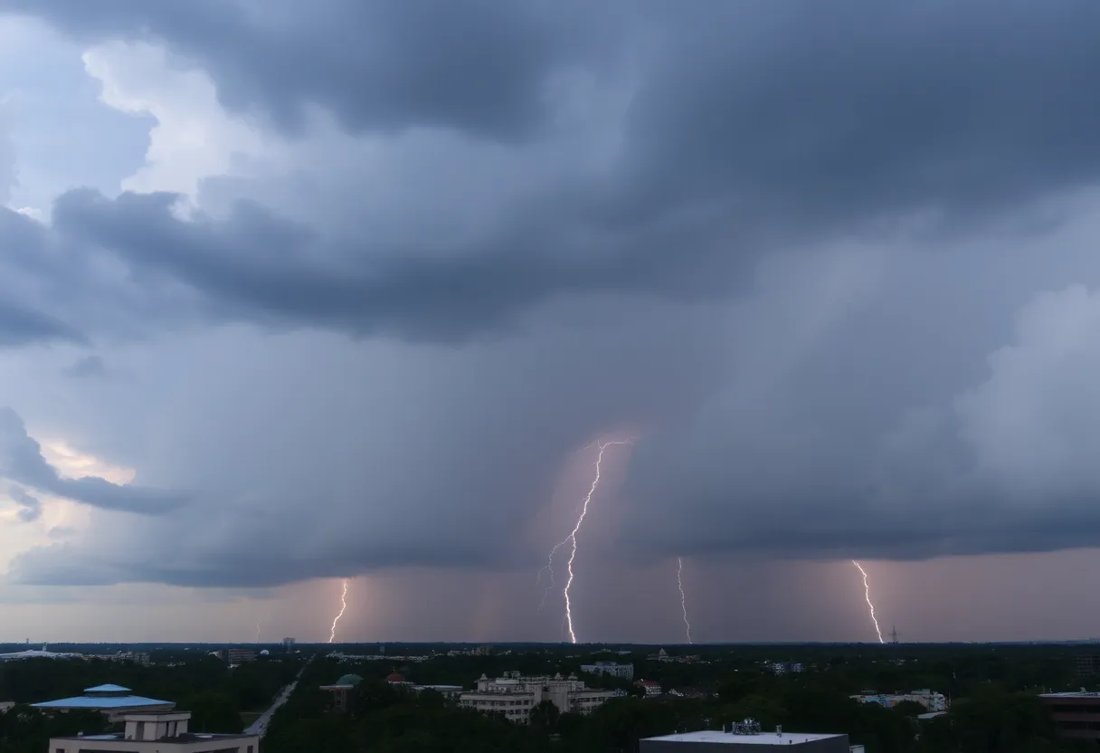
Residents of Charleston, South Carolina are currently under a Severe Thunderstorm Warning and Flash Flood Alerts. The National Weather Service issued warnings for Charleston County as heavy precipitation, exceeding an inch in some areas, threatens to cause flash flooding. Areas such as Hollywood, Ravanel, and Meggett may experience gusts up to 60 mph along with pea-sized hail. While the flash flood warning for downtown Charleston has expired, rainfall could still reach up to 3 inches. Officials advise residents to remain vigilant as weather conditions evolve.
Charleston, South Carolina: Severe Thunderstorm Warning and Flash Flood Alerts Issued
The National Weather Service (NWS) has issued a Severe Thunderstorm Warning for parts of Charleston County effective until 4:15 p.m. today. Additionally, a Flash Flood Warning has been announced for downtown Charleston due to heavy precipitation that has exceeded an inch in some areas. Residents in impacted regions are advised to stay vigilant as conditions may worsen.
Areas impacted by the Severe Thunderstorm Warning include Hollywood, Ravanel, and Meggett, where wind gusts could reach up to 60 mph. There is also the potential for pea-sized hail in these areas. Doppler radar has identified a strong thunderstorm near Switzerland, moving south at a speed of 5 mph. This storm is producing winds up to 50 mph and torrential rainfall, contributing to the heightened risk of flash flooding.
The flash flood warning for downtown Charleston expired at 3:15 p.m., although anticipatory rainfall amounts could approach 3 inches before the storm exits the region. Floodwaters had previously blocked several streets in downtown Charleston but those routes have since reopened. Officials continue to monitor the situation closely to ensure public safety.
Impact of the Weather System
The severe thunderstorms impacting Charleston are part of a broader weather system that includes non-tropical low-pressure areas affecting the region. Emergency management officials are now focusing on new criteria for issuing Flood Advisories and Flash Flood Warnings, aiming to provide the public with clearer and more consistent communication regarding flooding risks.
This initiative by the Charleston NWS aims to align local warning systems with national standards. As a result, residents may see an increase in the number of flood-related warnings issued, shifting from approximately 95 Flood Advisories and 19 Flash Flood Warnings issued over the past year. However, officials clarify that this does not indicate an increased risk of flooding but rather an improvement in public information.
Continued Caution Advised
Despite the upcoming changes to the warning system, operational procedures for emergency response teams will remain unchanged. Flooding caused by tidal issues will still be managed through Coastal Flood Warnings and Storm Surge Warnings, distinct from Flash Flood notifications.
NWS data indicates that lightning strikes the United States approximately 25 million times each year, resulting in around 20 fatalities annually. In tandem with active weather events, residents are urged to be aware of hazardous conditions like hydroplaning, which occurs when a vehicle slides uncontrollably on wet roads due to water accumulation in front of tires.
To stay updated on the latest weather information, residents are encouraged to rely on NOAA Weather Radio All Hazards, local TV broadcasts, or news sources.
Weather Advisory Summary
- Severe Thunderstorm Warning until 4:15 p.m.
- Flash Flood Warning issued for downtown Charleston due to over an inch of rain
- Strong thunderstorms producing winds of up to 60 mph
- Potential for additional rainfall up to 3 inches
- Flash flood warning expired at 3:15 p.m.
- New criteria for warnings to improve public communication
FAQ
What is the Severe Thunderstorm Warning?
A Severe Thunderstorm Warning indicates that dangerous thunderstorms capable of producing strong winds, hail, and heavy rain are occurring in the area.
What areas are affected by the Flash Flood Warning?
The Flash Flood Warning is specifically for downtown Charleston.
How much rainfall is expected?
Rainfall amounts could reach up to 3 inches by the time the storm exits the region.
What should residents do during severe weather alerts?
Residents should stay informed about the latest weather updates and avoid traveling in flooded areas.
Key Features of Severe Weather Alerts
| Feature | Description |
|---|---|
| Severe Thunderstorm Warning | Issued for severe thunderstorms with potentially damaging winds and hail. |
| Flash Flood Warning | Issued for areas with heavy rainfall that may cause flash flooding. |
| Rainfall Expectations | Potential for up to 3 inches of rain before storm passage. |
| Emergency Communication | Improvements aim to clarify flood risks for residents. |
| Public Recommendations | Stay informed via NOAA and avoid flooded areas. |
Deeper Dive: News & Info About This Topic
HERE Resources
Severe Weather Causes Havoc in Jasper County, Mississippi
Severe Thunderstorms Hit Spartanburg, South Carolina
Severe Thunderstorm Warnings for Coastal Colleton and Beaufort Counties
Severe Thunderstorm Warnings for South Carolina Counties
Strong Thunderstorms Hit Columbia, South Carolina!
Severe Thunderstorms and Flood Alerts Impact South Carolina
Severe Thunderstorm Alert in South Carolina
Severe Thunderstorm Warnings Hit Charleston County!
Tropical Storm Erin Takes Shape: South Carolina on Alert
Charleston to Revamp Flash Flood Warning Criteria for Safety
Additional Resources
- Island Packet: Severe Thunderstorm Warning for Charleston
- Wikipedia: Thunderstorm
- Count on 2: Flash Flood Warning for Charleston Area
- Google Search: Charleston Weather Alerts
- Live 5 News: Flooding Closes Downtown Charleston Streets
- Encyclopedia Britannica: Flood
- ABC News 4: Severe Thunderstorm Warning for Charleston County
- Google News: Severe Thunderstorm Charleston
- Fox Weather: Charleston Flood Alerts and Warnings
- Google Scholar: Thunderstorm Warnings Charleston

Author: STAFF HERE HILTON HEAD
The HILTON HEAD STAFF WRITER represents the experienced team at HEREHiltonHead.com, your go-to source for actionable local news and information in Hilton Head Island, Beaufort County, and beyond. Specializing in "news you can use," we cover essential topics like product reviews for personal and business needs, local business directories, politics, real estate trends, neighborhood insights, and state news affecting the area—with deep expertise drawn from years of dedicated reporting and strong community input, including local press releases and business updates. We deliver top reporting on high-value events such as the RBC Heritage golf tournament, Hilton Head Island Wine & Food Festival, and the Gullah Celebration. Our coverage extends to key organizations like the Hilton Head Island-Bluffton Chamber of Commerce and Community Foundation of the Lowcountry, plus leading businesses in tourism and hospitality that power the local economy such as Sea Pines Resort and Sonesta Resort Hilton Head Island. As part of the broader HERE network, including HEREAiken.com, HEREBeaufort.com, HEREChapin.com, HERECharleston.com, HEREClinton.com, HEREColumbia.com, HEREGeorgetown.com, HEREGreenwood.com, HEREGreenville.com, HEREHiltonHead.com, HEREIrmo.com, HEREMyrtleBeach.com, HERENewberry.com, HERERockHill.com, and HERESpartanburg.com, we provide comprehensive, credible insights into South Carolina's dynamic landscape.


