News Summary
The National Weather Service has issued a severe thunderstorm alert for Coastal Georgia and South Carolina, affecting areas including Hilton Head Island and Savannah. Residents should prepare for wind gusts up to 50 mph, frequent lightning, and potential road impacts on major highways. This follows a previous alert for thunderstorms earlier in the week, compounded by heavy rainfall that set new historical records for Charleston. Residents are advised to stay informed through various media outlets as the storm approaches.
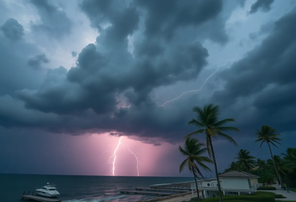
Charleston, SC – The National Weather Service (NWS) has issued an updated weather alert for severe thunderstorms affecting Coastal Georgia and South Carolina, with warnings issued on Sunday at 6:04 p.m. The alert remains in effect until 6:45 p.m., covering areas including Inland Jasper, Coastal Jasper, and Beaufort County. Residents can anticipate wind gusts reaching up to 50 mph, alongside frequent cloud-to-ground lightning associated with the storm.
Doppler radar at 6:04 p.m. tracked a strong thunderstorm over Burroughs, moving eastward at a speed of 15 mph. Along with wind gusts that could knock down tree limbs and disperse unsecured objects, the storm poses a significant risk of lightning strikes that may occur up to 10 miles away from the thunderstorm itself. Key locations impacted by the storm include Hilton Head Island, Pooler, Bluffton, Tybee Island, and parts of Savannah, including Downtown and Midtown as well as Fort Pulaski National Monument.
Critical roadways affected by the severe weather include high-traffic routes such as I-16 between mile markers 159 and 168, I-95 in Georgia between mile markers 100 and 101, and I-516 between mile markers 3 and 9. The NWS recommends that residents remain updated via NOAA Weather Radio, television, or local news broadcasts for the latest information regarding the storm.
The alert followed a previous warning issued by the NWS on Saturday at 3:31 p.m., which highlighted strong thunderstorms in Coastal Colleton and Charleston County until 4 p.m. that day. Thunderstorms observed included peaks in wind gusts up to 50 mph and instances of penny-sized hail. Doppler radar indicated a strong storm over Bennetts Point, moving northeast at 10 mph, with areas affected including Bennetts Point, Edisto Island, and Wiggins. While storms in the Tri-County area (Charleston, Berkeley, and Dorchester Counties) cleared earlier, isolated severe thunderstorms remained possible.
Furthermore, previous weather systems have caused severe weather conditions in the region. Charleston faced road flooding from heavy rainfall earlier in the month, breaking historical rain records. Charleston International Airport reported 1.99 inches of rainfall since midnight on Saturday, surpassing a record that had stood since 1952. Meanwhile, Downtown Charleston experienced 2.06 inches of rain, exceeding a record from 1899. The heavy rain prompted Flash Flood Warnings across parts of Alabama, Florida, and South Carolina.
A slow-moving storm system is notably predicted to continue affecting the area, potentially bringing over 4 inches of rain to select locations, especially where thunderstorms persist. As this weather system is expected to drift into the Tennessee Valley, rainfall may continue to spread into the Carolinas and Virginia. Most areas are under an expected rainfall total of 3 to 5 inches, with isolated amounts in western North Carolina and Virginia possibly reaching up to 7 inches.
In light of the ongoing and impending weather events, the NWS advises that residents take precautions during thunderstorms, including seeking safe shelter inside buildings or vehicles. The likelihood of lightning strikes rises as thunderstorms approach, peaking when storms are right overhead. Annually, the United States records approximately 25 million lightning strikes, with about 20 leading to fatalities each year. Therefore, it is critical for residents to stay informed and prepared as storms continue to develop in the region.
Deeper Dive: News & Info About This Topic
HERE Resources
Severe Thunderstorm and Flash Flood Alerts Hit York County
Severe Thunderstorm Warnings Hit Southeastern North Carolina
Severe Thunderstorm Warning for Greenville and Spartanburg
Severe Thunderstorm Warning Issued for Pickens County, SC
Hilton Head Island Airport Invites Artists for Terminal Artwork
Severe Thunderstorm Warnings Issued for South Carolina Counties
Severe Thunderstorm Warnings Hit Midlands Region of South Carolina
Thunderstorms Rolling Through Darlington County
Severe Thunderstorm Warnings in South Carolina: Stay Safe!
Severe Thunderstorm Alert Issued for South Carolina
Additional Resources
- Island Packet: Severe Thunderstorm Warning
- Wikipedia: Thunderstorm
- Live 5 News: Thunderstorm Warning Alert
- Google Search: Thunderstorm Weather
- Count on 2: Tornado Warning Issued
- Google Scholar: Severe Weather Impact
- Myrtle Beach Online: Weather News
- Encyclopedia Britannica: Weather Alert
- Fox Weather: Flash Flood Threat
- Google News: Flash Flood Warning
- Post and Courier: Thunderstorms and Power Outages
- Google Search: Thunderstorm Power Outage

Author: STAFF HERE HILTON HEAD
The HILTON HEAD STAFF WRITER represents the experienced team at HEREHiltonHead.com, your go-to source for actionable local news and information in Hilton Head Island, Beaufort County, and beyond. Specializing in "news you can use," we cover essential topics like product reviews for personal and business needs, local business directories, politics, real estate trends, neighborhood insights, and state news affecting the area—with deep expertise drawn from years of dedicated reporting and strong community input, including local press releases and business updates. We deliver top reporting on high-value events such as the RBC Heritage golf tournament, Hilton Head Island Wine & Food Festival, and the Gullah Celebration. Our coverage extends to key organizations like the Hilton Head Island-Bluffton Chamber of Commerce and Community Foundation of the Lowcountry, plus leading businesses in tourism and hospitality that power the local economy such as Sea Pines Resort and Sonesta Resort Hilton Head Island. As part of the broader HERE network, including HEREAiken.com, HEREBeaufort.com, HEREChapin.com, HERECharleston.com, HEREClinton.com, HEREColumbia.com, HEREGeorgetown.com, HEREGreenwood.com, HEREGreenville.com, HEREHiltonHead.com, HEREIrmo.com, HEREMyrtleBeach.com, HERENewberry.com, HERERockHill.com, and HERESpartanburg.com, we provide comprehensive, credible insights into South Carolina's dynamic landscape.


